Suppose it were a white granite city, standing on a ridge so elevated that it appears to be within the clouds. Thick jungle concealed this Inca citadel for more than four hundred years. It rests four breathtaking thousand feet above sea level. If you’ve ever wondered where is Machu Picchu, the answer lies deep within the mist-covered peaks of the Peruvian Andes.
Geographically, the site rests at 13.1631° S, 72.5450° W, suspended above the roaring waters of the Urubamba Valley in the Cusco Region. Due to the fact that Spanish conquistadors had never known of Machu Picchu, its elaborate stonework remained in almost perfect isolation.
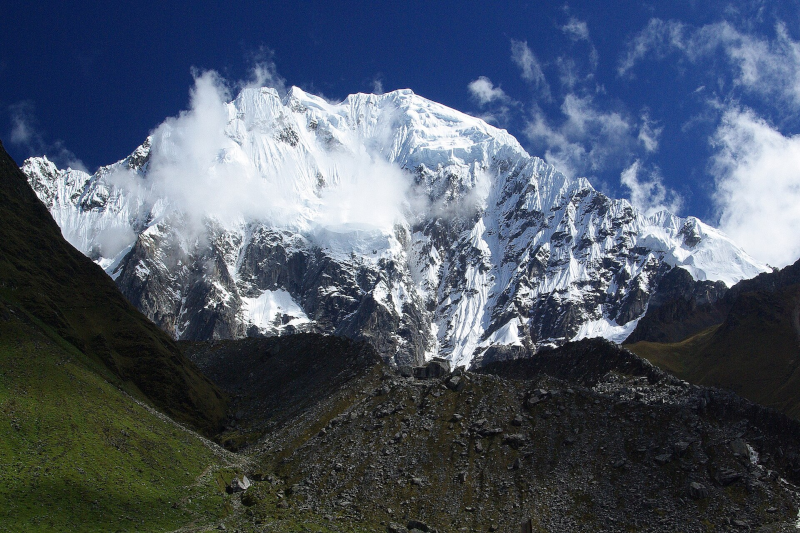
An accurate location of Machu Picchu shows how nature contributed to the fact that the rest of the world has remained oblivious to the presence of this engineering marvel.
Where Is Machu Picchu in the World? Pinpointing the Citadel’s Hidden Coordinates
Most travelers know Machu Picchu is in Peru, but few understand the mountain range where it sits, which explains why it remained hidden for centuries. The ruins are far into the Cordillera de Vilcabamba, a rocky outcropping of the central Andes that serves as a wild border between the alpine high plateaus and the fertile basin of the Amazon.
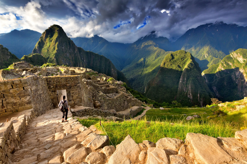
Despite the fact that Europeans erected castles on observable hills, the location of the site indicates that the builders wanted to keep it a secret. The citadel sits on a steep saddle of granite between the two towering mountains—Machu Picchu (Old Mountain) and the finer, well-known mountain of Huayna Picchu (Young Mountain).
The geography provides a dreadful vertical defense. Although Machu Picchu surely belongs to the Andes, the site reminds more of an island in the sky. Below this still, the Urubamba River winds round at the foot of the mountain like a moat, and left an almost sheer drop of 1,500 feet that made an assault over the valley floor next to impossible.
To find the location on the map, one would have to examine the location on the “cloud forest” which is a zone of transition between warm jungle moisture and cold mountain stone. This rare ecosystem covers the ridges with perpetual fog and thick plants, a natural shield which prevented access to the Spanish conquistadors and preconditioned the discovery of this marvel by an explorer many centuries later.
The 1911 Revelation: How Hiram Bingham ‘Found’ a City That Wasn’t Lost
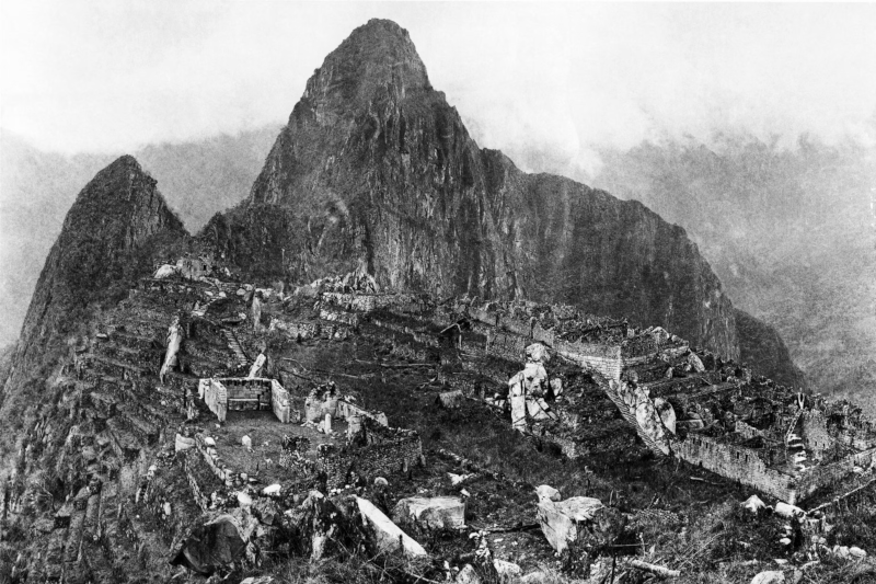
Historical accounts tend to portray Hiram Bingham as an adventurer who was able to uncover the fabled city of Vitcos by mere chance, whereas a Yale professor was searching to find the lost city. As the head of the Yale Peruvian Expedition of 1911, he was hoping to find the last stronghold of the Inca rebellion against the Spaniards. Bingham took his grave thinking that he had discovered “Lost City”, and was not aware that he had discovered a royal country estate and not a military fortress of Vilcabamba.
The real credit of discovering the concealed Incan citadel goes to a wide extent to the native guides who helped with the quest. Some local innkeeper, Melchor Arteaga, heard us talk of ruins on the old mountain, and conducted the American to the spot at the end of a silver sol.
The Journey That Led to the Discovery
The chain of occurrences leading to the international publicity of the site took a very quick turn:
- July 23: The expedition camped at Mandor Pampa, where Arteaga described extensive ruins high above.
- July 24: Bingham climbed the humid slopes accompanied only by Arteaga and a forceful police sergeant.
- The Reveal: A young local boy led Bingham through the thick vegetation to his first glimpse of the pristine white granite temples.
- The Misidentification: Bingham mapped the site, erroneously believing it was Tampu-tocco or the lost capital of Vilcabamba.
Those initial findings sparked massive excavation efforts backed by National Geographic and Yale, eventually leading to complex debates over artifact repatriation a century later. Although wrong in his theories of the site identification, Bingham was right in his awe.
The Fortress of Silence: Why the Spanish Conquistadors Never Saw It
The 16th-century conquest devastated many Incan cities, as conquerors tore down temples to build Catholic churches and melted artistic valuables to obtain bullion. Never was it only that the conquistador troops did not repeat these granite walls, and only that they did not find them. As the Spanish plundered the local capital of Cusco, they moved directly over the foot of the mountain, and never saw the enormous sanctuary that lay in the clouds overhead.
Geography served as a final line of defense of this kingly retreat. The steep Puncuyoc range defended the site to the east, and the rapids of the Urubamba River protected it to the west, isolating it from the main military routes. The Incas historically used the terrifying terrain of the Sacred Valley for defense. When they retreated, they destroyed the access bridges, removing these ruins from the known world.
That deliberate seclusion made a time casket perfect. What was the secret behind Machu Picchu? The elite established it as a private estate rather than a government center. This is what made the architecture remain as it was intensified by its creators without any colonialism touches and prepared us to imagine the citadel in all its glory.
From Granite to Grandeur: What the Incan Citadel Looked Like in 1450
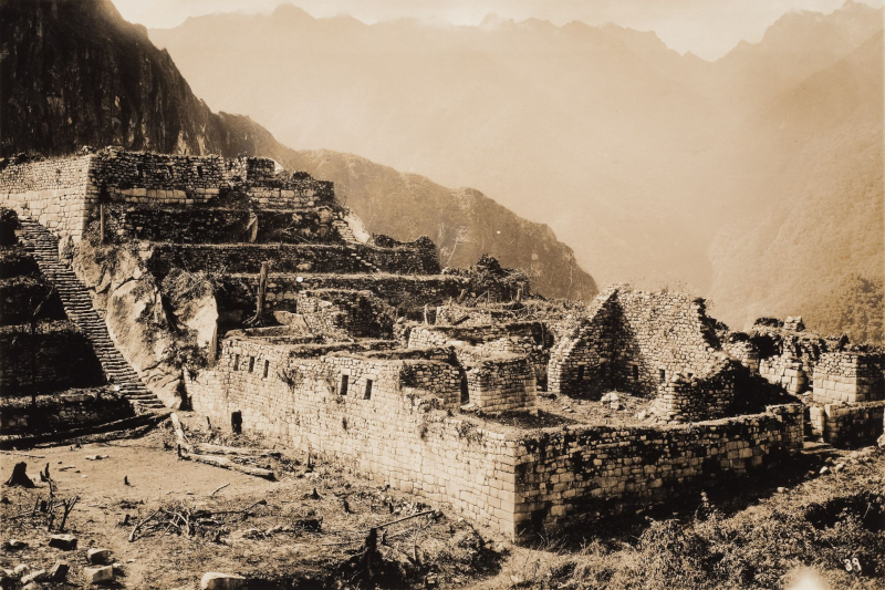
To paint the picture of the Incan citadel in its full glory, it is necessary to color the grey ruins that one can observe nowadays. Its location was an energetic facility in 1450 with roofs of dense, yellow ichu grass atop the stone buildings to shield its inhabitants against severe rains in the Andes.
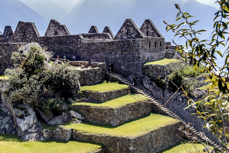
The biggest enemies here were the gravity but the builders conquered it by the grand scale of engineering. Scientific mapping of Incan terrace systems indicates that the 700+ green steps that surrounded the city did not just grow important crops and thus play a role in supporting crops but it provided the mountain slope a corset to ensure their stability against landslides.
Maybe the most notorious accomplishment is the stonework which is based on the pre-Columbian architectural skills instead of using mortar. Such precision with which granite blocks are cut is that they fit together as puzzle pieces and the walls would dance during earthquakes and not fall down.
The following architectural facts contribute to the determination of the most important elements of the site:
- The Intihuatana: A sun hitching post, which was employed in religious ceremonies.
- The Sacrosanctaugh: The Temple of the Sun, the Room of Three Windows.
- The Industrial Sector: The artisans lived and worked separately from the nobility.
A Wonder of the World: Why This High-Altitude Sanctuary Matters Today
The transformation of a backyard belonging to the local farmer into the UNESCO World Heritage site transforms these ruins into the result of indigenous survival. The estate was marked to be best in its architecture and ability to blend in with the surroundings, hence showing just the reasons which made Machu Picchu a wonder of the world. It confirms that Incas were mighty engineers who could come up with long-term legacies in the skies.
The site became one of the Seven Wonders of the World in 2007. Conservation efforts now focus on protecting the granite stones from the impact of modern tourism. Although the original enigma was an intrigue to the West, the true wonder is how the site has remained standing over the centuries after numerous earthquakes and jungles.
When you read the history of Machu Picchu, look beyond the mist-covered photos. The story no longer centers on a Western discovery, but on a history the people of the Andes never lost, which changes how we understand the Andean past.
Q&A
Question: Where exactly is Machu Picchu located? Short answer: Machu Picchu is in Peru’s Cusco Region at 13.1631° S, 72.5450° W, perched 2,430 meters above sea level. It overlooks the Urubamba Valley and sits on a narrow granite saddle between Machu Picchu (“Old Mountain”) and Huayna Picchu (“Young Mountain”).
Question: Which mountain range contains Machu Picchu, and why did that setting keep it hidden for so long? The citadel is constructed far into the Cordillera de Vilcabamba, a rugged severance of Andes traversing high plateau and Amazon basin. Its cloud forest-like ambience; its ever-misting air, its thick growth and steep, jungled ridges served as natural disguise. The Urubamba River winds below like a moat and the sheer drops about the location formed great vertical barriers that repelled approach and sight.
Question: Why did not the conquistadors of the Spanish discover or destroy Machu Picchu?In brief: Geography and secrecy saved it. Isolated were the site and main military routes by the Puncuyoc range, and the rapids of the Urubamba River. Whenever the Incas were on the retreat, they were able to demolish the few access bridges so as to conceal the same. It was hardly a social city because it was a personal royal estate that was little known by common people, especially elites. This served in the preservation of the granite architecture.
History and Discovery of Machu Picchu
Question: Was Machu Picchu truly “lost” until Hiram Bingham’s 1911 expedition? No not to native inhabitants. The site was familiar to the indigenous farmers. Following local innkeeper Melchor Arteaga who had said that there were ruins on the “Old Mountain,” Bingham arrived at the citadel on July 24, 1911. He discovered the Recharte and Alvarez homes on the terraces. He surveyed the ruins and mistaken it to be Tampu-tocco or the lost capital of Vilcabamba.
Question: What did Machu Picchu resemble approximately 1450 and the way Inca engineering has allowed it to be so resilient? The property was in stone buildings that were surrounded with yellow ichu grass roofs and over 700 agricultural terraces which were all green. The terraces made the slopes stable and curbed landslides. The Incas used granite blocks that were cut with high precision so that they could fit without a mortar.